180
180
Sep 30, 2010
09/10
by
WTTG
tv
eye 180
favorite 0
quote 0
. >> paul wagner inside and talk about some high water problems in virginia. didn't take long before the low- lying stretch of browns mill road was flooded in vienna. a car partly submerged. you see it there and turn around. >>> flooding problems in maryland as well. there have been reports of possible waterspouts and waves can causing coastal flooding and let's continue in maryland and bob barnard is live in annapolis and taking a beating from the heavy rains and mixing the tide, bob and that is a real mess. >> reporter: that's right, high tide is not for another 5 1/2 hours and that is coming out of the city dock harbor here and over the sidewalk. you can see, we'll follow it across here and that is underwater and the street here and businesses are closed and there he is on sand bags and in front of the ice crime shop and was basically damaged and destroyed, $40,000 in repairs them and spoke this time -- to them a short time ago. >> i'm unnerved by this because high tide is not supposed to be until 11:30. >> i get a few more sand bags, i will make it. >> not
. >> paul wagner inside and talk about some high water problems in virginia. didn't take long before the low- lying stretch of browns mill road was flooded in vienna. a car partly submerged. you see it there and turn around. >>> flooding problems in maryland as well. there have been reports of possible waterspouts and waves can causing coastal flooding and let's continue in maryland and bob barnard is live in annapolis and taking a beating from the heavy rains and mixing the...
143
143
Sep 30, 2010
09/10
by
WJLA
tv
eye 143
favorite 0
quote 0
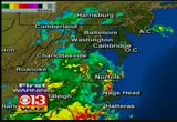
has been at work for us all day long, showing the further south -- the rain is further south toward virginia beach. this is the next batch. i cannot tell you exactly where the heaviest rain will fall. the indications are that it will be along and east of the i-95 corridor. this event will go mostly all night long with more heavy rain. 4.3 interest in prince frederick. -- 4.3 inches in prince frederick. 81 and 66, a warm, tropical, windy day with a lot of rain in the bucket. the overall area under a flash flood watch until about midnight tonight. a lot of things will change. this next big batch of rain is coming up from the south. buie at 81 degrees. definitely a tropical field in the air. by tomorrow, this latest storm system, which has incorporated what is left of tropical storm nicole, that will move up the chesapeake bay and make a turn to the right early in the morning. then we are on target to have a great stretch of whether as we head through the remaining afternoon hours into the weekend. as we head through the late- night hours, more heavy rain after 11:00 p.m. that is why you have t
has been at work for us all day long, showing the further south -- the rain is further south toward virginia beach. this is the next batch. i cannot tell you exactly where the heaviest rain will fall. the indications are that it will be along and east of the i-95 corridor. this event will go mostly all night long with more heavy rain. 4.3 interest in prince frederick. -- 4.3 inches in prince frederick. 81 and 66, a warm, tropical, windy day with a lot of rain in the bucket. the overall area...
147
147
Sep 30, 2010
09/10
by
WUSA
tv
eye 147
favorite 0
quote 0
. >>> over to virginia, they haven't had quite as much rain, but plenty of people are still trying to dry out. suray chin is live where she has been checking out all the damage there. >> the flooded streets are just down the road from here. the water came fast and furious on brownsmill road. when it comes to these types of conditions, the neighborhood is on edge. >> whenever we get a lot of rain like this, i am keeping my eye on the water, the river. >> kate gets nervous in the downpour. the creek that often overflows its banks runs along the home where she's a full-time nanny to three small children. >> it got pretty crazy, to be honest. we had a lot of flooding in the backyard. it became a river, and actually we are surrounded on all sides. we became an island with the neighbors. >> last month, high waters surrounded the home in the front, side, and backyard. today, a much better outlook. even the bridge that crumbled the last go around was in tact. thanks to vdot workers who helped clear debris across the region. >> this is typical of what you'll see when you get a lot of rain. thi
. >>> over to virginia, they haven't had quite as much rain, but plenty of people are still trying to dry out. suray chin is live where she has been checking out all the damage there. >> the flooded streets are just down the road from here. the water came fast and furious on brownsmill road. when it comes to these types of conditions, the neighborhood is on edge. >> whenever we get a lot of rain like this, i am keeping my eye on the water, the river. >> kate gets...
215
215
Sep 30, 2010
09/10
by
WJZ
tv
eye 215
favorite 0
quote 0
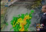
mary's and portions of western dorchester down into portions of virginia. a little bit more on this. bernadette joins me. >> these numbers will start going up. the next round is on its way. we've had over nine inches of rain. the airport alone we've seen those numbers. over 7 1/2 at the naval acady. salisbury will be on the way up. now the thing is, there are a lot of warnings going on. flash flood warnings have been extended. you see all of those counties. this has been extended until 12:15 a.m. in addition to that, still officially a tornado watch if -- in effect through 7:00 tonight. that severe weather threat at been the biggest problem. underneath we're seeing coastal flood warnings. that's because the winds have been sustained at 20 to 25 miles an hour. this turned around to the northwest. the band shifted to the east, cranked our wind around to the now. i don't think that's the trend. it will not push the water back out tomorrow. we'll keep you updated. mary? >> wjz has been tracking the flooding conditions all day in baltimore county. derek valcourt
mary's and portions of western dorchester down into portions of virginia. a little bit more on this. bernadette joins me. >> these numbers will start going up. the next round is on its way. we've had over nine inches of rain. the airport alone we've seen those numbers. over 7 1/2 at the naval acady. salisbury will be on the way up. now the thing is, there are a lot of warnings going on. flash flood warnings have been extended. you see all of those counties. this has been extended until...
156
156
Sep 30, 2010
09/10
by
WBFF
tv
eye 156
favorite 0
quote 0
and this low will continue to move along frontal boundaryy6 3 right through north ccrolina ttrough virginia and then into maryland as e go through the úvernight.so we are still seeing potential foo heavy amounts of rainffll through thh over night. also gusty winds. winds from 10 to 25 miles an hourrat times very breezy conditions out there. the very unstable atmosphere as well that's why we have the potential for maybe some rumble of thunder tonight and storm and that chance wwllated lessen andddefinitell all have to deal with the rain. over parts of tte renal and continue to follow this storm and monitor it.i'll give you 7 day forecast coming up and show you when the systems leaving us finaaly inna bit. than 25 people injurrd. it happened just after 7 this morning at university úoulevard west at brunette avenue in silver springs. some passengers or high school injuries.no life threatening >> dozen people are injuredd some hospitalized tonight when a tour bus plunges off a highway on wednesday in bethesda. bus crashed into a guard ail hit a baariir then down a hill. several kids aboard as
and this low will continue to move along frontal boundaryy6 3 right through north ccrolina ttrough virginia and then into maryland as e go through the úvernight.so we are still seeing potential foo heavy amounts of rainffll through thh over night. also gusty winds. winds from 10 to 25 miles an hourrat times very breezy conditions out there. the very unstable atmosphere as well that's why we have the potential for maybe some rumble of thunder tonight and storm and that chance wwllated lessen...
203
203
Sep 30, 2010
09/10
by
WJLA
tv
eye 203
favorite 0
quote 0
and the virginia football team is scrambling to come up with a new game plan. take a look at this giant sinkhole, 30 feet wide and 15 feet deep that has opened up in the middle of the practice field. the coach noticed that the field had a scrushy feeling hours before it opened up. no one was hurt. >> squishy feeling, you bet. i'm guessing the rain has got things complicated out there, right? >> actually, it is moving along pretty well. it looks like there's a lot of low volume out there. maybe because it was so crazy this morning that many people did not make it to work. there are significant delays usually. that is not the case today. the beltway at colesville, extremely low volume making things very easy. in the places that it is raining and you will see a little bit of worst traffic. 270 north at 121, obviously, the delays are starting to build their and they will be significant no problem on 95 southbound heading from springfield to newington. >> coming up, two americans go missing in ileanit tilley and ty are missing in a hot air balloon. >> they call it t
and the virginia football team is scrambling to come up with a new game plan. take a look at this giant sinkhole, 30 feet wide and 15 feet deep that has opened up in the middle of the practice field. the coach noticed that the field had a scrushy feeling hours before it opened up. no one was hurt. >> squishy feeling, you bet. i'm guessing the rain has got things complicated out there, right? >> actually, it is moving along pretty well. it looks like there's a lot of low volume out...
160
160
Sep 30, 2010
09/10
by
WUSA
tv
eye 160
favorite 0
quote 0
to over northern virginia, manassas. that line of thunderstorms will continue a northerly movement and that will have heavy rain fall. i don't doubt, 1 to 2-inch rain fall per hour over the next several hours. we will fill in more rain here in washington through the next several hours. topper. >> let's look at the model now. this is our rain potential and again, you see the sharp edge of some pretty significant rain. an inch or so up to 5 inches of rain. that's why we are saying an additional 1 to 5 inches of rain is possible. so round 2, critical time. 10:00 p.m. to 6:00 a.m. the bulls eye is east and southeast of town unfortunately and allow extra time tomorrow and please, if you can, tell commute, if you are lucky enough to do that. there will be more street flooding tomorrow. we love to have your pictures, e-mail them to photos, go on our facebook and dc flood if you would. now in addition to the rain, we have some winds. winds gusting to 28 miles per hour downtown. 32 miles per hour at easten and a 25-mile per hour
to over northern virginia, manassas. that line of thunderstorms will continue a northerly movement and that will have heavy rain fall. i don't doubt, 1 to 2-inch rain fall per hour over the next several hours. we will fill in more rain here in washington through the next several hours. topper. >> let's look at the model now. this is our rain potential and again, you see the sharp edge of some pretty significant rain. an inch or so up to 5 inches of rain. that's why we are saying an...
102
102
Sep 30, 2010
09/10
by
WBAL
tv
eye 102
favorite 0
quote 0
you will see that tropical moisture extends down to virginia and the carolinas. accumulation estimates pretty much right up the bay and on the western shore, four-7 inches so far with 5-10 inches with parts of calvert county. it looks like some of that area will get hit hard tonight. the western shore shifting over to the eastern shore, another 5 inches of rain may come down. flood warnings are up all over our region. there's also a tornado watch until 7:00 this evening. they may produce tornadoes. lots of other problems as the remnants of nicole comes our way. monitoring the conditions in downtown baltimore is jane miller. they are dealing with the wind pushing up the bay. >> i am standing at the harbor and behind me i can feel the wind against my back. we will show you what you were talking about. this is the promise not area. -- promenade. all that area and the waterfront, everyone is keeping a close eye on that water level. the safety manager of the baltimore national aquarium kept watch on the rising water levels around the harbor. >> is this starts flooding
you will see that tropical moisture extends down to virginia and the carolinas. accumulation estimates pretty much right up the bay and on the western shore, four-7 inches so far with 5-10 inches with parts of calvert county. it looks like some of that area will get hit hard tonight. the western shore shifting over to the eastern shore, another 5 inches of rain may come down. flood warnings are up all over our region. there's also a tornado watch until 7:00 this evening. they may produce...
241
241
Sep 30, 2010
09/10
by
WRC
tv
eye 241
favorite 0
quote 0
this was the scene in norfolk, virginia, this morning. as you can see, this entire section was under water. other roads across the city also flooded. rescue teams had to help some motor is who got stranded when their car stalled. and flooding's causing big problems up in baltimore as well. sevennches of rain fell before 11:00 this morning and several roads are closed because of standing water or outright flooding. >>all of this wet weather has a lot of people asking, what does homeowners insurance cover when it comes to water damage. it is not as straightforward as you might think. the insurance information institu breaks it down for us. if water comes from the sky, such as rain leaking in your roof, homeowners insurance will cover that damage. if t water comes from the ground up as a result of a swollen creek or if standing rainwater seps into your basement, you are not covered. that's when your flood insurance kicks in. but you have to have flood insurance. it's a federal flood insurance policy that you have to buy for that kind of dama
this was the scene in norfolk, virginia, this morning. as you can see, this entire section was under water. other roads across the city also flooded. rescue teams had to help some motor is who got stranded when their car stalled. and flooding's causing big problems up in baltimore as well. sevennches of rain fell before 11:00 this morning and several roads are closed because of standing water or outright flooding. >>all of this wet weather has a lot of people asking, what does homeowners...
208
208
Sep 30, 2010
09/10
by
WJZ
tv
eye 208
favorite 0
quote 0
look at when's coming across virginia and the carolinas. extreme tropical moisture is moving directly toward our region. i well take a closer view and look at the rainfall numbers. just take a look at when's happening. a batch of heavy rain and thunderstorms across portions of frederick county headed to our west. another batch coming from the south. heavy rain to the south of our region right now. that will look at the rainfall totals. some are extremely impressive particularly along the bay. all along the bay corridor, 5, 6, 7, 8 inches in some spots. we've had reports of 10 inches. eastern shore a lot less. it is a quick cutoff. 3 inches or so, 2 1/2 out to the west. right along the bay, just east of the city, harford county right through eastern baltimore county is where we've seen the high, high rainfall totals. these are just estimates. some areas have had even more. joining me now bernadette woods has had a look at the numbers. some are really incredible. >> even where it falls off, we're talking a few inches of rain. the highest amou
look at when's coming across virginia and the carolinas. extreme tropical moisture is moving directly toward our region. i well take a closer view and look at the rainfall numbers. just take a look at when's happening. a batch of heavy rain and thunderstorms across portions of frederick county headed to our west. another batch coming from the south. heavy rain to the south of our region right now. that will look at the rainfall totals. some are extremely impressive particularly along the bay....
293
293
Sep 30, 2010
09/10
by
WRC
tv
eye 293
favorite 0
quote 0
dominion tells us more than 3,000 mers are in the dark in northern virginia. vg & e says 17,000 people are without power. petco is reporting prince georges county and the district. >>> we'll find out what's going on with our traffic out there. hey, ashley. >> hey, barbara. 270 is open today. at least we're a little bit ahead of ourselves or at least ahead of yesterday. we do have problems around the region. around the capital belt way, this is the -- path kennel worth, now we're looking at route 4, but earlier it would be an accident up towards the greenbelt metro. elsewhere around town, eltway the inneroop around nelson. the outer loop will start to slow leaving the american legion headed in towards tyson. we may have a new accident there on the far right side of the roadway with drivers slamming on their brakes. if you head around the silver spring ea, not too bad. but very blustery out there. we do have power lines that are down and out. out of virginia, gallows at columbia pike is not working at last check. >> thanks, ashley. >> thanks, ash. >>> the bad we
dominion tells us more than 3,000 mers are in the dark in northern virginia. vg & e says 17,000 people are without power. petco is reporting prince georges county and the district. >>> we'll find out what's going on with our traffic out there. hey, ashley. >> hey, barbara. 270 is open today. at least we're a little bit ahead of ourselves or at least ahead of yesterday. we do have problems around the region. around the capital belt way, this is the -- path kennel worth, now...
171
171
Sep 30, 2010
09/10
by
WJZ
tv
eye 171
favorite 0
quote 0
. >> reporter: fast-moving floodwaters are making driving impossible in parts of virginia. roads are either washed out or shut down. some people had to leave their cars behind while others pushed their way out. firefighters rescued a woman after her car got stuck in the water. the only road into this henry county community flooded but some people refused to stay put. >> i'm going to work. the only way to get there is to go through that water. >> reporter: on the north carolina coast, the best way to get down the street is by boat. close to 2 feet of water have fallen on care row lynn that beach shutting -- carolina beach shutting down the ports of town. >> unbelievable. i've never seen anything like it. >> reporter: more is on the way. after of an early morning soaking, new york city got a break from the rain. high wind warnings and flood watches are in effect. meteorologists warn a tornado could hit. commuters in washington d.c. drove through high water, and there were a lot of accidents on slick roads. in maryland, one bus smashed into the back of another injuring 25 peop
. >> reporter: fast-moving floodwaters are making driving impossible in parts of virginia. roads are either washed out or shut down. some people had to leave their cars behind while others pushed their way out. firefighters rescued a woman after her car got stuck in the water. the only road into this henry county community flooded but some people refused to stay put. >> i'm going to work. the only way to get there is to go through that water. >> reporter: on the north carolina...
194
194
Sep 30, 2010
09/10
by
CNN
tv
eye 194
favorite 0
quote 0
brianna keilar, cnn, arlington, virginia. >> so can i eat it or not? can i? all right. maybe the answers are going to be at cnn.com/eatocracy. i was really paying close attention to that to figure out what i can eat tonight. i still don't know. for mo >>> we are going to take a check of the weather here coming up. i just saw a live picture a moment ago of a couple of live reporters where it was really coming down. maybe we're going to check in with them here shortly as well. it's coming down in buckets along the eastern seaboard today. tropical storm leftovers likely to mean flooding. heading to the cnn severe weather center, next. ♪ [ male announcer ] ever have morning pain slow you down? introducing bayer am, an extra strength pain reliever with alertness aid to fight fatigue. so get up and get goin'! with new bayer am. the morning pain reliever. >>> taking look right now at some of the stories making headlines, we want to start at ft. hood in texas where there have been apparently four suicides there over the weekend. that is in addition to 14 other suicides at ft.
brianna keilar, cnn, arlington, virginia. >> so can i eat it or not? can i? all right. maybe the answers are going to be at cnn.com/eatocracy. i was really paying close attention to that to figure out what i can eat tonight. i still don't know. for mo >>> we are going to take a check of the weather here coming up. i just saw a live picture a moment ago of a couple of live reporters where it was really coming down. maybe we're going to check in with them here shortly as well. it's...
227
227
Sep 30, 2010
09/10
by
FOXNEWS
tv
eye 227
favorite 0
quote 0
, i talked to congressman frank wolf, he's been very involved in this issue, he's a republican from virginia, leading the charge. he says that he and a number of other members had repeatedly asked the house judiciary committee to launch an investigation into these claims and he's calling out the attorney general. take a listen: >> eric holder has a moral responsibility, legal, too, but a moral responsibility to the american people to clear this up. and there ought to be -- this ought to be neutral issue, there ought not be decisions based on the color or the background of a person. the law is the law, and the law should be enforced. >> reporter: so i asked the congressman point blank if republicans take back the house in november will they launch an investigation, he said i don't care who's in charge the house come november, i'm going to keep on pushing to get someone to start a congressional inquiry, rick. rick: shannon bream, live from washington, thanks. jenna: this story reads like a cold war spy novel, two members of congress, pushing to revoke the u.s. visas of 60 russian officials. wh
, i talked to congressman frank wolf, he's been very involved in this issue, he's a republican from virginia, leading the charge. he says that he and a number of other members had repeatedly asked the house judiciary committee to launch an investigation into these claims and he's calling out the attorney general. take a listen: >> eric holder has a moral responsibility, legal, too, but a moral responsibility to the american people to clear this up. and there ought to be -- this ought to...
257
257
Sep 30, 2010
09/10
by
WTTG
tv
eye 257
favorite 0
quote 0
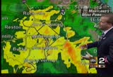
., maryland and virginia coming up. fox 5 morning news at 7:00 starts right now. >>> and good morning. thank you for staying with us. i'm gurvir dhindsa, filling in for steve today. >> i'm allison seymour. the loss of a hollywood legend, actor tony curtis has died at the age of 85. we'll look back at his career in just a moment. >>> first let's take a look outside. it is the story we're dealing with right now. straight up 7:00 and tony perkins is on the desk with you and a very busy man today, both he and tucker. what is going on, tony? >> we continue to see moderate to heavy rainfall move through the area. we have a variety of warnings and watches in effect at this time. i'll let you know first of all that the tornado warning that was in effect for portions of maryland has been taken down now. it's been allowed to expire. that tornado warning that was in effect for portions of maryland. now let's look at hd radar and we'll show you where the heavy precipitation is as we speak. and as we've been seeing all morning long,
., maryland and virginia coming up. fox 5 morning news at 7:00 starts right now. >>> and good morning. thank you for staying with us. i'm gurvir dhindsa, filling in for steve today. >> i'm allison seymour. the loss of a hollywood legend, actor tony curtis has died at the age of 85. we'll look back at his career in just a moment. >>> first let's take a look outside. it is the story we're dealing with right now. straight up 7:00 and tony perkins is on the desk with you and...
595
595
Sep 30, 2010
09/10
by
WRC
tv
eye 595
favorite 0
quote 0
eat falls, virginia. we can zoom in and show you where they are getting the heaest rain right now as well asear the dulles tollway where it meets reston by dulles airport. that's where they're getting heavy rain right now. the streams are flowing out of their banks. we have an update. that's passing to north. ts is the latest radar. this is live, showing you what's going on. very heavy rains right now in far northern fairfax county crossing the potomac and heading into montgomery county and heading up toward darnestown and toward poolsville in the next few minutes. it will pass to the west near gaithersburg and barnesville and clarksburg and sugar loaf mountain. this area may get more flooding from creeks and streams there. now, the wider view, showing pocketing of heavier rain. just now coming into charles county out of the northern neck of virginia. that area of heavy rain is now moving right near just to the southwest of waldorf. that is as we look here at the radar showing one really heavy downpour ju
eat falls, virginia. we can zoom in and show you where they are getting the heaest rain right now as well asear the dulles tollway where it meets reston by dulles airport. that's where they're getting heavy rain right now. the streams are flowing out of their banks. we have an update. that's passing to north. ts is the latest radar. this is live, showing you what's going on. very heavy rains right now in far northern fairfax county crossing the potomac and heading into montgomery county and...
637
637
Sep 30, 2010
09/10
by
WBAL
tv
eye 637
favorite 0
quote 0
president obama addressed voters in virginia that said he had no idea how to reduce the nation's deficit. >>> and pilot jack conroyd called the landing the most significant thing that happened to him in 32 years of flying. he praised his crew saying he was no hero, adding, he was just doing his job. >>> hollywood legend tony curtis died last night of cardiac arrest at his home in nevada. in a career that spanned 59 years and was in "some like it hot" and the father of jamie curtis, he was 85. back to matt and vieira, certainly a huge loss. >> and jamie lee i >> at the tropical downpours ever since after midnight last night still affecting our entire area. tornado watch in effect until 1:00. rain likely in excess of si >>> that's your latest weather. matt. >> thank you very much. to politics and two controversial tea party candidates making waves ir there in a respective states. nbc kelly o'donnell is in washington with this. good morning to you. >> reporter: good morning, matt. politics often gets personal and confrontational. it's unusual to see major candidate pile over like this. new
president obama addressed voters in virginia that said he had no idea how to reduce the nation's deficit. >>> and pilot jack conroyd called the landing the most significant thing that happened to him in 32 years of flying. he praised his crew saying he was no hero, adding, he was just doing his job. >>> hollywood legend tony curtis died last night of cardiac arrest at his home in nevada. in a career that spanned 59 years and was in "some like it hot" and the father...
465
465
Sep 30, 2010
09/10
by
WJLA
tv
eye 465
favorite 0
quote 0
i will take you to virginia with substantial delays this morning. the main and hov lanes are bad. >>> we have a lot of rain to deal with in the morning and the afternoon. we have a tornado watch until 1:00 this afternoon and a flash flood warning this morning and a wind advisory for calvert, anne arundel, and st. mary's county until 8:00 this evening. the doppler radar says the heaviest rain is across the bay and the rest of the area has moderate rain, 2-5 inches are expected and daytime highs will only be in the 70's. tonight it will clear after midnight and temperatures fall to 60 and a change for the day tomorrow, 76 degrees with lots of sunshine. >>> that is the reward, thank you. we'll be back with another update at 8:27. for continuous news coverage, tune in to tbd news on news channel 8. what's all this? big news! we have another way to help you save. oh, really? how? by bundling. if you get your homeowners and auto insurance together, we give you even more savings. ooh! big bundle. [ chuckling ] home and auto together. it's like peanut butte
i will take you to virginia with substantial delays this morning. the main and hov lanes are bad. >>> we have a lot of rain to deal with in the morning and the afternoon. we have a tornado watch until 1:00 this afternoon and a flash flood warning this morning and a wind advisory for calvert, anne arundel, and st. mary's county until 8:00 this evening. the doppler radar says the heaviest rain is across the bay and the rest of the area has moderate rain, 2-5 inches are expected and...
334
334
Sep 30, 2010
09/10
by
WMAR
tv
eye 334
favorite 0
quote 0
so, i tracked her down in virginia to talk about what happened after all those cameras went away. it was the headline felt around the world. >> the woman who cut off her husband's penis. >> lorena bobbitt. >> attracted international attention. >> last thing i remember, i woke up. she just cut it off. >> i don't know why. he hurt me. >> reporter: 24-year-old lorena bobbitt said she had been sexually assaulted by her husband one too many times. so, she struck back with a kitchen knife, while her husband slept. >> years of violence and abuse, that she was unable to overcome her impulse to defend herself. >> reporter: while lorena was charged with malicious wounding, he was charged with marital sexual abuse. the trial transfixed america. joke about the bobbitts became a national pastime. and while both were found not guilty, lorena was evaluated and 45 days in a psychiatric institution. eventually, the frenzy died down. that was lorena then. and this is lorena now, 17 years later. a shy and petite 41-year-old mother, using her maiden name, lorena gallo. does it feel like a lifetime ag
so, i tracked her down in virginia to talk about what happened after all those cameras went away. it was the headline felt around the world. >> the woman who cut off her husband's penis. >> lorena bobbitt. >> attracted international attention. >> last thing i remember, i woke up. she just cut it off. >> i don't know why. he hurt me. >> reporter: 24-year-old lorena bobbitt said she had been sexually assaulted by her husband one too many times. so, she struck...
215
215
Sep 30, 2010
09/10
by
WBAL
tv
eye 215
favorite 0
quote 0
it will move up into the virginia and new york state. this is a flooding-type event. expecting inwe're excess of 4 inches. more likely, in excess of 6 inches. we have a flash flood warnings issued around the district of columbia and down to the south in annapolis. there is a coastal advisory with one to 2 feet above the normal high tide. into the mix, there is wind problems. we have tornado watch that extends for the entire area until 1:00 p.m. this afternoon and gusts up to 45 miles per hour. this will continue to move in our direction. there is no relief in sight until later tomorrow. heavy rains throughout today and may be some thunderstorms in the mix. we're in the 70's. 57 set 61. heavy rain even at 8:00 p.m. tonight. -- 57 to 61. we will clear out after 10:00 a.m. tomorrow. temperatures will be in the 60's on saturday. this is a dangerous tropical system we are tracking all day today. >> that translates into a m ess for the morning commute. eastbound 70 is shut down between 29 and the patapsco river bridge because of an overturned milk tanker. you are being forc
it will move up into the virginia and new york state. this is a flooding-type event. expecting inwe're excess of 4 inches. more likely, in excess of 6 inches. we have a flash flood warnings issued around the district of columbia and down to the south in annapolis. there is a coastal advisory with one to 2 feet above the normal high tide. into the mix, there is wind problems. we have tornado watch that extends for the entire area until 1:00 p.m. this afternoon and gusts up to 45 miles per hour....
219
219
Sep 30, 2010
09/10
by
WTTG
tv
eye 219
favorite 0
quote 0
let me move you into virginia. 66 gridlocked now out of manassas headed into centreville. inhe loop of the beltway, telegraph road for the crash. inbound dulles toll road in the airport lanes at hunter mill road for the accident. airport lanes are currently blocked. left lane in the main line is blocked with fire and rescue responding. 95 jammed up badly out of falmouth. in the service road at dale city, there is an accident with only the left lane able to squeeze through. 395 delays continuing in springfield. that's a check of your fox 5 on-time traffic. >> thank you so much. >>> tony is back. what is going on gentleman just came down during the last minute i'm tornado warning in effect. i was showing you those areas to the east. take a look at hd radar. tornado warning now in effect until 7:00 a.m. for southeastern calvert county in southern maryland and eastern st. mary's county in southern maryland. doppler radar indicates a severe thunderstorm capable of producing a tornado near st. mary's city. the storm is moving to the north at 40 miles per hour. locations that cou
let me move you into virginia. 66 gridlocked now out of manassas headed into centreville. inhe loop of the beltway, telegraph road for the crash. inbound dulles toll road in the airport lanes at hunter mill road for the accident. airport lanes are currently blocked. left lane in the main line is blocked with fire and rescue responding. 95 jammed up badly out of falmouth. in the service road at dale city, there is an accident with only the left lane able to squeeze through. 395 delays continuing...
384
384
Sep 30, 2010
09/10
by
WBFF
tv
eye 384
favorite 0
quote 0
as we get closer to where the area as seen the eaviest rain, ú%'s been to the south in virginia where we pick up an3 inch. ú% we looo at vvrginia, if we can ppck that up and et closer. you can see we haveeshowers tha3 are heavver to the east of the beltway, actually toward the edgemere and dundalk it looks like. indicating where the rain has southeast to the north and west and will continue toodo so. we willlwiden things out once that are seeing a decent amount of rain. -oo can see the west side of the beltway, we will get closer now. youucannsee as we get closer to the western side of the area, let's get closer toward ú%ederick and you can see new market street looking like we're going to see, or rather new market and some of thess streets yyu will see here. let's get a littlee3 -ddntification on the streets and you will see where you are.ú i-70 seeing heavy rain and 270 as well. we will continueeto see some of this activity moveetoward the north and the wess as 67 somm of thh shower activity areas that are seeing the hhaviest rain conninue to move in the northwesterly direction.
as we get closer to where the area as seen the eaviest rain, ú%'s been to the south in virginia where we pick up an3 inch. ú% we looo at vvrginia, if we can ppck that up and et closer. you can see we haveeshowers tha3 are heavver to the east of the beltway, actually toward the edgemere and dundalk it looks like. indicating where the rain has southeast to the north and west and will continue toodo so. we willlwiden things out once that are seeing a decent amount of rain. -oo can see the west...
293
293
Sep 30, 2010
09/10
by
CNN
tv
eye 293
favorite 0
quote 0
but a couple of scares on virginia beach proper. so heavy, heavy rain with this. boy, i'll tell you what, wilmington has just gotten pounded with rain for the past four days now. 20 inches of rainfall. and they'll get several more today. so this is the most rain that they've ever seen, at least in a three-day period, let alone, a four or five-day period. you can see it continues to stream in here. so that's going to be the main issue. and then also some winds. you see winds gusting over 40 miles an hour in north carolina. last night in south carolina, we had a wind gust measured at over 60 miles an hour. society saturation of the ground, coupled with a little bit of wind, you're going to see trees down and power outages. this food watch goes all the way up to the canadian border. this say huge, huge system affecting a lot of people. ground stop at teterboro. you're not flying there? >> no, i'm not in that league. >> a lot of major metropolitan airports are under significant delays. >> i notice delta has canceled at least one flight from atlanta to new york. >> the
but a couple of scares on virginia beach proper. so heavy, heavy rain with this. boy, i'll tell you what, wilmington has just gotten pounded with rain for the past four days now. 20 inches of rainfall. and they'll get several more today. so this is the most rain that they've ever seen, at least in a three-day period, let alone, a four or five-day period. you can see it continues to stream in here. so that's going to be the main issue. and then also some winds. you see winds gusting over 40...
193
193
Sep 30, 2010
09/10
by
WTTG
tv
eye 193
favorite 0
quote 0
beach area this morning for virginia beach, norfolk and the eastern city of chesapeake. so that is a tornado warning in effect down to our south and east. now, let's get to hd radar. i just want to mention while we are atalking about these tornado watches that are in effect, this is how widespread the system is. tornado watch is in effect for portions of the district of columbia, delaware, maryland, new jersey and the costal waters. we are particular will you currented about our friends in anne arundel county, calvert county, places like that where they continue to see -- look at annapolis, right now under the gun. cape st. clair under the gun with very heavy rain. they just keep getting the heavy rain. it has been consistent there. other parts of the area, you have heavy rain and lighter amounts of rainfall. most of the washington area is getting heavy rain. all of the areas in yellow and orange that you see, getting heavy rain. bethesda, mclean, vienna, arlington. that is what we're watching this morning. right now, current conditions being reported at reagan national
beach area this morning for virginia beach, norfolk and the eastern city of chesapeake. so that is a tornado warning in effect down to our south and east. now, let's get to hd radar. i just want to mention while we are atalking about these tornado watches that are in effect, this is how widespread the system is. tornado watch is in effect for portions of the district of columbia, delaware, maryland, new jersey and the costal waters. we are particular will you currented about our friends in anne...
198
198
Sep 30, 2010
09/10
by
WJLA
tv
eye 198
favorite 0
quote 0
a crash i-70 at el con city remains closed. 95, virginia. i have a series of wrecks between the stafford airport and the occoquan river bridge. you'll be able to me an ander through all of them. but add 307 minutes to your normal commute. >> lisa, thank you for the latest. sad, breaking news out of hollywood. mourning the death of an icon this morning, abc news has learned oscar-nominated actor tony curtis has died. details are not being released about his death. his real name was bernard schwarts, well known for his role in "some like it hot." his co-stars were marilyn monroe and jack lemmon. he is the father of actress jamie lee curtis. he was 85 years old. i think "some like it hot" was one of the best movies ever. hysterical. >> made more than 100 movies. >> on a lighter note. it's been getting a lot of attention. jon stuart's march on washington. he's gotten a stamp of approval by the white house. president obama said he was so called amused by the call for restoring sanity and yesterday website publisher airiana huffington said she wou
a crash i-70 at el con city remains closed. 95, virginia. i have a series of wrecks between the stafford airport and the occoquan river bridge. you'll be able to me an ander through all of them. but add 307 minutes to your normal commute. >> lisa, thank you for the latest. sad, breaking news out of hollywood. mourning the death of an icon this morning, abc news has learned oscar-nominated actor tony curtis has died. details are not being released about his death. his real name was bernard...
164
164
Sep 30, 2010
09/10
by
WRC
tv
eye 164
favorite 0
quote 0
jerry has traffic. >> following breaking news in northern virginia. i ar just one of many accidents already out there this rning. you're looking at live pictures of an accident that occurred just minutes ago. this is 95 northbound near route 123 in woodbridge. you can see one vehicle spun sideways. left half of the roadway is currently blocked. this is one of two or three separate accidents on the 95 corridor in virginialready this morning. there was another one down around dunnfry. you're going to have to keep your speed way down this morning and just be aware of your surroundings. let's head on over to maryland, and update you on the inner loop of the beltway. authorities just dispatched for an accident, inner loop between conneccut avenue and georgia avenue. of course we had the tractor trailer jackknife reported inner loop after the i-270. in addition to 270 southbound, at leas one accident in rockville that authorities are on the scene dealing with right now. out on the rails, good option this morning, metro, vre m.a.r.c. doing fine so far. >> th
jerry has traffic. >> following breaking news in northern virginia. i ar just one of many accidents already out there this rning. you're looking at live pictures of an accident that occurred just minutes ago. this is 95 northbound near route 123 in woodbridge. you can see one vehicle spun sideways. left half of the roadway is currently blocked. this is one of two or three separate accidents on the 95 corridor in virginialready this morning. there was another one down around dunnfry....
165
165
Sep 30, 2010
09/10
by
WUSA
tv
eye 165
favorite 0
quote 0
also coming in from virginia. moving northward in to fairfax countiful travel will be tough just about anywhere. light to moderate rains in prince georges county. expand out and show you the heavy rains from annapolis down to western anne arundel in to calvert county and just in to the bay, in the northern neck. and this area of rain, we are talking about rain totals here have been incredible. this has difficulted to the bay as it is moving to the north. so far three to four inches of rain or more. upwards of five in to southern st. mary's county. kristin said the trampoline is gone and the winds. we had big winds and storms that rolled in earlier. and this is just the beginning. a lot of light to moderate rain covering everybody but the yellow and oranges are the heaviest in the metro and.s south. on the weather computer, we will give you the tour. the moisture continues to stream in from the bahamas up here through north central, eastern north carolina. most of virginia, maryland, up through pennsylvania, new yo
also coming in from virginia. moving northward in to fairfax countiful travel will be tough just about anywhere. light to moderate rains in prince georges county. expand out and show you the heavy rains from annapolis down to western anne arundel in to calvert county and just in to the bay, in the northern neck. and this area of rain, we are talking about rain totals here have been incredible. this has difficulted to the bay as it is moving to the north. so far three to four inches of rain or...
139
139
Sep 30, 2010
09/10
by
WJZ
tv
eye 139
favorite 0
quote 0
just south of the city, the rains are moving in and south to us into virginias and carolinas. it is heading due north and will be heavy at times and during the day tomorrow we do have flash flood watches in effect and coastal -- the entire region all day tomorrow into the evening hours, too. also a high wind watch for the eastern shore and the beach areas as well. bernadette woods joins me now from the out back with a close look at the storm and what we can expect rain wise. >> reporter: declassified from an extra tropical storm, however, it is still spinning out there and throwing a lot of moisture our way. and the overall pattern is already directing moisture our way. the thing is along this path you can see with the arrows what's going up and down the highway to draw all the moisture northward. so over this region you see it's heaviest up to 6 seasons. it's something we are concerned about. we will keep you updated. right now back inside. >>> first warning coverage continues now. kei jackson explains what's being done around the region to prepare for all this rain. >> repor
just south of the city, the rains are moving in and south to us into virginias and carolinas. it is heading due north and will be heavy at times and during the day tomorrow we do have flash flood watches in effect and coastal -- the entire region all day tomorrow into the evening hours, too. also a high wind watch for the eastern shore and the beach areas as well. bernadette woods joins me now from the out back with a close look at the storm and what we can expect rain wise. >> reporter:...
125
125
Sep 30, 2010
09/10
by
WMAR
tv
eye 125
favorite 0
quote 0
begins to douse places like virginia and down through the carolina's. bottom line more wet weather will be the pattern here and you can see the leading edge of the storm and there will be more and more of this training up the coast. let's show you downtown. rain hasn't come in quite yet. 67 degrees and humidity high at 81%. that could help fuel quite a bit of leafy wet weather. so far so good. just trace amounts today across the immediate baltimore area. a less than a 20th of inch of rain. winds not to gusty yet. those rainfall totals further south of us beginning to come up a little bit. we have a third of an inch in hunting town. these are the -- all right. let's show you the humidity. high, air nearly saturated. that is going to help fuel the rain as it comes in. very large area of heavy wet weather through norfolk. they are getting a lot of rainfall. the whole thing tracks further and further north. talled front along the coast. we are optimistic it'll begin to move out to seef. it stalls out we could see more rain. it's rain that won't be welcome.
begins to douse places like virginia and down through the carolina's. bottom line more wet weather will be the pattern here and you can see the leading edge of the storm and there will be more and more of this training up the coast. let's show you downtown. rain hasn't come in quite yet. 67 degrees and humidity high at 81%. that could help fuel quite a bit of leafy wet weather. so far so good. just trace amounts today across the immediate baltimore area. a less than a 20th of inch of rain....
163
163
Sep 30, 2010
09/10
by
WTTG
tv
eye 163
favorite 0
quote 0
. >>> in virginia now it appears the serial burglar struck again last night. in fact, he struck eight times last night. tonight fairfax county police are stepping up efforts to end what they call a one-man crime spree. we're talking 82 incidents in less than two months across the county including the clifton, sully, fair oaks, reston and mcclain areas. fox 5's wisdom martin working that one tonight. >> reporter: police say it's a top priority putting as many resources as they can into this crime spree regardless of their budget and the schedule. so far there have been no face to face confrontations with the suspect, but now investigators think the burglar may be armed. [ applause ] it was standing room only at mills elementary. hundreds of concerned residents packed the cafeteria to hear police information about the serial burglar that has plagued homeowners more than a month. >> normally we feel pretty safe in this area and i think that everybody is extremely concerned. i get multiple e-mails a day from neighbors all over the area. >> reporter: last night eig
. >>> in virginia now it appears the serial burglar struck again last night. in fact, he struck eight times last night. tonight fairfax county police are stepping up efforts to end what they call a one-man crime spree. we're talking 82 incidents in less than two months across the county including the clifton, sully, fair oaks, reston and mcclain areas. fox 5's wisdom martin working that one tonight. >> reporter: police say it's a top priority putting as many resources as they can...
154
154
Sep 30, 2010
09/10
by
WUSA
tv
eye 154
favorite 0
quote 0
look at the heavy rains through eastern north carolina and southeastern virginia. that's what's headed for the morning commute. we'll tighten up to close in view around the immediate metro area on the computer and we'll see moderate rain moving in from the metro area from the south. this is like a tropical conveyor belt, really. we'd like you to help sending them to the website, post on facebook or tweet, and go to twitter and please tag your tweets with dc flood and we'll put them on the air as soon as possible. overnight, rain and thunderstorms go into effect. lows of 60 and 65. i'll come back with breakdown of weather and rain fall amounts for your area. . >> down in alexander ria, crews are clearing drains hoping to clear the potential of high water. they've seen this sort of thing before. earlier tonight, trailer trucks loaded with sand bags made deposits at king and lee streets. meantime over in annapolis, the city is keeping a big eye on a aging dam. that 90-year-old dam's foundation is eroding and there are gaping cracks in the wall. regulators have deemed
look at the heavy rains through eastern north carolina and southeastern virginia. that's what's headed for the morning commute. we'll tighten up to close in view around the immediate metro area on the computer and we'll see moderate rain moving in from the metro area from the south. this is like a tropical conveyor belt, really. we'd like you to help sending them to the website, post on facebook or tweet, and go to twitter and please tag your tweets with dc flood and we'll put them on the air...
211
211
Sep 30, 2010
09/10
by
WBAL
tv
eye 211
favorite 0
quote 0
the threat of rain which is just coming up out of virginia and southern maryland, will be with us for a while. is heavy as you get down to parts of eastern north carolina. that is one thing will have to watch for tomorrow, the potential for severe storms embedded in this batch of heavy rain. so far the -- only. 02 of rain so far officially. we are still running cool, 65, frederick county in the low 60s, and it gets chilly out in western maryland in the 50's. tropical like air is already starting to feed up into southern maryland. the air is loaded with moisture, so look for some showers in the region in the morning. breezy, 58-65 to start off thursday. nicole did not last very long. it was gone by 5:00 in the afternoon, but the remnants of it down here are still loaded with tropical moisture and this area of low pressure, combined with new ones on this stalled front will bring all the tropical moisture into the mid atlantic. we are in for some heavy rain and may be severe thunderstorms as well. rod brown baltimore and on to the eastern shore tomorrow afternoon, watch for gusty winds.
the threat of rain which is just coming up out of virginia and southern maryland, will be with us for a while. is heavy as you get down to parts of eastern north carolina. that is one thing will have to watch for tomorrow, the potential for severe storms embedded in this batch of heavy rain. so far the -- only. 02 of rain so far officially. we are still running cool, 65, frederick county in the low 60s, and it gets chilly out in western maryland in the 50's. tropical like air is already...
203
203
Sep 30, 2010
09/10
by
WRC
tv
eye 203
favorite 0
quote 0
several others re trapped, and 270 was closed for five hours, clogging the evening rush hour way into virginia. >> this is a look at the crash site from chper 4 tonight. interstate 270 north reopened about 90 minutes ago. traffic now is finally getting back to normal. jack bensen is at suburban hospital where family members are arriving to be with the injured. we're with craig where it was just a news conference. craig? >> reporter: we'll get to that news komps conference in a secot everybody on the scene said it was horrifying to see the bus on that embankment the. they're going to be working with the marynd state police hand lipg the investigation, and they told me a short time ago that it could be some time before we know what happened. >> it was just before 4:00 that the bus fell over the flyover. >> i think it just slipped over there. >> moments later, other people who had pulled over started screaming. >> those are the kids, those are the kids. ey all were screaming and some of them were out and then they were handed to me. i just stay with them. >> reporter: the kids would be okay. they
several others re trapped, and 270 was closed for five hours, clogging the evening rush hour way into virginia. >> this is a look at the crash site from chper 4 tonight. interstate 270 north reopened about 90 minutes ago. traffic now is finally getting back to normal. jack bensen is at suburban hospital where family members are arriving to be with the injured. we're with craig where it was just a news conference. craig? >> reporter: we'll get to that news komps conference in a secot...
296
296
Sep 30, 2010
09/10
by
WBFF
tv
eye 296
favorite 0
quote 0
all of ceetral virginia eastern virginia under this watch as well. heading to south we have tornadoes watches over the carolinas, as this volatile wwather shifts north. we have a potentiallof sseing tornado watches tomorrow. potentiil for isolated tornadoee with the spinning of the aamosphere. so something to watch and keep3 you posted with any severe weather details as it becomes available if we nned to for tomorrow. heavy rain makes the way outtof the carolinas to virginia. riding along the frontal boundary. in fact, time thing out on the futurr scan. looking at seven a.m..3 rush hour. a mess. give yourself extra time tomorrow orning. with heavy rainfall. and same ffr lunch hour. and by evening sooe of it heads ú%re of the energy startsstor head out over the atlantic. we see it start to get breaks from the rain friday and into the weekend. tonight, 71 degrees. %-tomorrow turn storms. in pace. isolated tornado r so. watch for that. definitely heavy rainfall throuuh the afterroon. with temperatures around 77. aad then your five-day forecast. shoos t
all of ceetral virginia eastern virginia under this watch as well. heading to south we have tornadoes watches over the carolinas, as this volatile wwather shifts north. we have a potentiallof sseing tornado watches tomorrow. potentiil for isolated tornadoee with the spinning of the aamosphere. so something to watch and keep3 you posted with any severe weather details as it becomes available if we nned to for tomorrow. heavy rain makes the way outtof the carolinas to virginia. riding along the...
319
319
Sep 30, 2010
09/10
by
WTTG
tv
eye 319
favorite 0
quote 1
. >>> hard to imagine, but the commute in northern virginia could soon get worse. the eye popping results of a traffic test completed before thousands of extra commuters cram into one very shawl space. >>> the judges table may look a lot different, but the local contestants are still as nervous as ever. we'll take you to the first round of idol auditions up in jersey next. ananiges ananiges words alone aren't enough. my job is to listen to the needs and frustrations of the shrimpers and fishermen, hotel or restaurant workers who lost their jobs to the spill. i'm iris cross. bp has taken full responsibility for the clean up in the gulf and that includes keeping you informed. our job is to listen and find ways to help. that means working with communities. restoring the jobs, tourist beaches, and businesses impacted by the spill. we've paid over $400 million in claims and set up a $20 billion independently-run claims fund to cover lost income until people impacted can get back to work. and our efforts aren't coming at tax-payer expense. i know people are wondering-- n
. >>> hard to imagine, but the commute in northern virginia could soon get worse. the eye popping results of a traffic test completed before thousands of extra commuters cram into one very shawl space. >>> the judges table may look a lot different, but the local contestants are still as nervous as ever. we'll take you to the first round of idol auditions up in jersey next. ananiges ananiges words alone aren't enough. my job is to listen to the needs and frustrations of the...
161
161
Sep 29, 2010
09/10
by
KQED
tv
eye 161
favorite 0
quote 0
sanders partee helped start the company three years ago with one customer, red top cab in northern virginia. its c.o.o., george pakidis, says its a hit. already one out of ten of his customers book rides that way. >> the idea that a client can reach us through the web, they can call us from their smart phone, they can text us, it's just user friendly. >> reporter: taximagic software can help take the load off a cab company's dispatch system. >> if you can see on the phone where the cab is on it's way to pick you up, you're less likely to call the operator and say, "dude, where's my car?" >> reporter: taximagic began with a business plan to integrate taxi charges into expense account software. but when it launched the taximagic smart phone app, things really took off. the service is now available in 30 metro areas, including san francisco, chicago and los angeles. >> i don't think we would be here if there wasn't such a thing as the iphone. our business was nice of the blackberry and nice on the web, but when the iphone came out was when everything went crazy. >> reporter: and just as everyt
sanders partee helped start the company three years ago with one customer, red top cab in northern virginia. its c.o.o., george pakidis, says its a hit. already one out of ten of his customers book rides that way. >> the idea that a client can reach us through the web, they can call us from their smart phone, they can text us, it's just user friendly. >> reporter: taximagic software can help take the load off a cab company's dispatch system. >> if you can see on the phone...
189
189
Sep 29, 2010
09/10
by
WUSA
tv
eye 189
favorite 0
quote 0
sometimes there would be roaches in the tray. >> reporter: the medicare virginia state fraud office asked if she would allow the fbi to put a camera in her husband's room and she said yes. with the evidence on the video, they were able to indict 11 employees on charges ranging from neglect and forgery to assault and battery. the worst case involves a male nurse who is accused of and apparently caught on tape holding a pillow over mr. evan's' face. the nurse charged in the pillow incident is 30-year-old john diaz. his trial is coming up next month. this woman, a nurse's aid, has already been convicted of assault. she's seen in a video laughing while she throws popcorn as mr. evans as he tries to bat it away. evans has filed a $10 million lawsuit against potomac center and the holding company genesis health care and 35 other defendants. his attorney said these problems are rampant in for- profit nursing homes. >> this is not one person, a rogue employee, this is the whole -- virtually the whole medical staff there. >> reporter: potomac said the resident in question received appropriate care
sometimes there would be roaches in the tray. >> reporter: the medicare virginia state fraud office asked if she would allow the fbi to put a camera in her husband's room and she said yes. with the evidence on the video, they were able to indict 11 employees on charges ranging from neglect and forgery to assault and battery. the worst case involves a male nurse who is accused of and apparently caught on tape holding a pillow over mr. evan's' face. the nurse charged in the pillow incident...
135
135
Sep 29, 2010
09/10
by
WJLA
tv
eye 135
favorite 0
quote 0
shifting back to read. >> virginia is a microcosm -- another sees states like virginia shifting back to red. >> insides republicans. >> rebecca cooper for battleground 2010 -- it insights republicans. >> thanks for joining us. i am gordon peterson. >> and i am leon harris. stay with abc7 news for all of your election coverage. good night. my dad is the supervisor of a train station and my mom's a teacher. my dad's an auto technician. my mom's a receptionist. i'm not sure i would have been able to afford college without the tuition freeze. while tuition in other states is rising out of reach... governor o'malley made the tough choice to freeze tuition. he made my dream of going to college into a reality. i'm the first in my family to go to college. my brother and i never would have been able to afford college. even though times were tough... governor o'malley kept his promise. there's never a doubt... there's never a doubt whose side he's on. martin o'malley... moving maryland forward. with the most locations is becoin the dc area,e bank. we figured they could use our help. ♪ down a
shifting back to read. >> virginia is a microcosm -- another sees states like virginia shifting back to red. >> insides republicans. >> rebecca cooper for battleground 2010 -- it insights republicans. >> thanks for joining us. i am gordon peterson. >> and i am leon harris. stay with abc7 news for all of your election coverage. good night. my dad is the supervisor of a train station and my mom's a teacher. my dad's an auto technician. my mom's a receptionist. i'm...
213
213
Sep 29, 2010
09/10
by
WMAR
tv
eye 213
favorite 0
quote 0
part of the state bottom line eastern shore included in this as well as far western maryland northern virginia. along the immediate chesapeake bay these bluer shaded are also under a coastal flood advisory especially over the next couple approaching high tides in the overnight and first high tide on the day above average high tides. so that's the concern with the coastal low coming up out of the south. we're going to look for gust he winds tomorrow. not a lot of wind right now. in fact winds calm. temperatures 66. so cool evening, bjipartly clo and you really wouldn't think anything is up but it is. again it's going to take a couple more hours to get in here. just about a trace of an inch of rain most spots well south y& of baltimore nothing north of town. and again blue skies today quickly giving way to cloudy skies getting a little more ominous looking outs there late into the afternoon. as that storm makes its 8move. temperature wise 60s now humidity very high. air is almost saturated that's going to help fuel these showers and downpours as they come in overnight. satellite radar trend ch
part of the state bottom line eastern shore included in this as well as far western maryland northern virginia. along the immediate chesapeake bay these bluer shaded are also under a coastal flood advisory especially over the next couple approaching high tides in the overnight and first high tide on the day above average high tides. so that's the concern with the coastal low coming up out of the south. we're going to look for gust he winds tomorrow. not a lot of wind right now. in fact winds...
173
173
Sep 29, 2010
09/10
by
WUSA
tv
eye 173
favorite 0
quote 0
i know on the outer loop of the beltway toward virginia, that is very slow as well. no accidents just a lot of volume. >> patranya, thank you. >>> we want to go out to anita brikman as she is out on the scene and she's talking with assistant chief scott graham. anita, are you there? >> reporter: i am, lesli. and assistant chief is joining me to explain where we are. you can see all of the activity right behind me where they are still trying to clear the scene. >> anita at about 4:00 this afternoon, montgomery county fire rescue received a call for an accident on northbound 270 involving a bus. the units arrived on the scene, they found a 26-passenger limo- style bus that was traveling on northbound 270 from old georgetown road area. >> reporter: and it was up on the h.o.v. lane. >> it was entered the h.o.v. fly over which rejoined just below montrose road. the bus apparently left the roadway and careen add proximately 45 feet and came to rest against the jersey wall on northbound 270 coming from the democracy boulevard area. >> reporter: now we understand one fatalit
i know on the outer loop of the beltway toward virginia, that is very slow as well. no accidents just a lot of volume. >> patranya, thank you. >>> we want to go out to anita brikman as she is out on the scene and she's talking with assistant chief scott graham. anita, are you there? >> reporter: i am, lesli. and assistant chief is joining me to explain where we are. you can see all of the activity right behind me where they are still trying to clear the scene. >>...
125
125
Sep 29, 2010
09/10
by
WTTG
tv
eye 125
favorite 0
quote 0
remember, that was a hurricane when it crossed the virginia and north carolina border. we're on the strong side of that system. this area of low pressure will not be so much about the winds, although there will be some winds with it, especially from i-of 92 and east to the coast. 35, 40 miles per hour and so, strong enough to bring down some tree limbs and wires and may be trees in some instances because we have had a couple of rounds of wet weather especially on the del marva and that is possible that we could see some thunderstorms with it. some of those could be severe and i mean gusty winds and, yes, some could find enough sheer in the atmosphere and spinning and could occur mostly in the day tomorrow and from i- 95 east and that flash flood watch is up and that this is where the severe weather risk will be and you can see generally 95 and to the beaches. that is where we will watch for those potentially stronger thunderstorms and with gusty wins being a real problem. at 6:00, the model is overdone here and this is ahead of schedule. this is when that gets going and
remember, that was a hurricane when it crossed the virginia and north carolina border. we're on the strong side of that system. this area of low pressure will not be so much about the winds, although there will be some winds with it, especially from i-of 92 and east to the coast. 35, 40 miles per hour and so, strong enough to bring down some tree limbs and wires and may be trees in some instances because we have had a couple of rounds of wet weather especially on the del marva and that is...
169
169
Sep 29, 2010
09/10
by
WBAL
tv
eye 169
favorite 0
quote 0
there is much heavier rain down across southeast virginia and into the carolinas, all associated with what used to be tropical storm the cold. that has dissipated but the moisture is still coming our way. computer models indicate that a lot of rain will fall between now and friday evening. the red and yellow areas indicate four or 5 inches of rain, especially on the eastern shore and the lower eastern shore were heavy rain is possible. there may be some gusty thunderstorms as well. wind advisories have been posted near the bay. tides are expected to run around 2 feet above normal three the day tomorrow. there may be some minor coastal flooding due to the higher than normal ties until the storm can move out. we will check the complete forecast in a few minutes. >> officials around the state are getting ready for this storm. they say they are urging residents to clean off nearby storm drains to help with any flooding. b.g.e. says to get ready now, just in case you lose power. >> the concern we have is the high wind. that could bring down trees, power lines, and obviously with the heavy
there is much heavier rain down across southeast virginia and into the carolinas, all associated with what used to be tropical storm the cold. that has dissipated but the moisture is still coming our way. computer models indicate that a lot of rain will fall between now and friday evening. the red and yellow areas indicate four or 5 inches of rain, especially on the eastern shore and the lower eastern shore were heavy rain is possible. there may be some gusty thunderstorms as well. wind...
198
198
Sep 29, 2010
09/10
by
WJZ
tv
eye 198
favorite 0
quote 0
all of the rain across the virginias and carolinas is all moving up the 95 corridor. so probably after 9:00 or 10:00 we'll see moderate rain. after midnight heavy rain. we can also expect to see heavy rain. because of the rain coming our direction we have advisories that will go into e fact late -- effect late, late tonight. we have flash flood watches out and from the western shore from aa county to st. mary's. we have a high wind watch, but it may get wind gusts over 40 miles an hour. bernadette joins me now with a look at this massive storm. >>> as of 5:00 this is downgraded to a nontropical. it's still moving our way. ignore the fact that it's this but don't ignore the fact that the rain continues to follow in our direction. we just started dealing with it today. the heavier arounds are expected tonight and tomorrow. wind gusts, interior areas possibly up to 30 miles an hour. thises is the zone with the heaviest rain we expect all up and down the coastline. yes. it is possible that some areas could get up to six inches of rain. a couple inches of rain are possible
all of the rain across the virginias and carolinas is all moving up the 95 corridor. so probably after 9:00 or 10:00 we'll see moderate rain. after midnight heavy rain. we can also expect to see heavy rain. because of the rain coming our direction we have advisories that will go into e fact late -- effect late, late tonight. we have flash flood watches out and from the western shore from aa county to st. mary's. we have a high wind watch, but it may get wind gusts over 40 miles an hour....
155
155
Sep 29, 2010
09/10
by
WRC
tv
eye 155
favorite 0
quote 0
the toll road was jammed up out of virginia. and river roa a lot of drivers were taking that as their alternative to get over toward silver spring and back to the beltway, but that no longer is a very good option because river road is jammed near the beltway in both directions to either leave the beltway and get out of town orto head thwart it to bypass the issue. we still have drivers on the outer loop coming around from georgia avenue in order to continue onto to 270 north. but the difference is you can continue only 270 north because you're on e spur at that point. but inner loop drivers are still forced to come around and not continue onto 270 but rather follow the pass and then silver spring. jim and door reap, back to you. >> this is expected to go on for hours and hours, isn't it? >> yes. so hopefully we'll get a solid work around. just for now, avoid it if you can. >> ashley, one thing i'm wondering about is people trying to get to dulles airport to make flights. any suggestions for them? >> well do, not commit to the be
the toll road was jammed up out of virginia. and river roa a lot of drivers were taking that as their alternative to get over toward silver spring and back to the beltway, but that no longer is a very good option because river road is jammed near the beltway in both directions to either leave the beltway and get out of town orto head thwart it to bypass the issue. we still have drivers on the outer loop coming around from georgia avenue in order to continue onto to 270 north. but the difference...
242
242
Sep 29, 2010
09/10
by
WBFF
tv
eye 242
favorite 0
quote 0
looking at a flood watch watch out of virginia, all across north viiginia, parts of the eastern shore and then also central maryland including %-d.c., down towards annapolis l incluued in this as we have the potential of heavy rainfall right along the central portion -f the mid portion of theestate so we'reevery concerned as the potential is there to get some heavy amounts of raan. the potential is there with the prediction here. %-theetrack of the storm.wing we could see anywhere from three to four inches, sooe areas maybe five, six inches in some that coulddcause this localized flooding because the ground is already saturated from the couple inches we got the other day, and now we're pouring more water on top of that. taking a look at where the rain is now. it's very light over balad, d.c., west of us still some showers. looking to the south of us you can see some heavy rain there overrthe carollnas. this is all riding along a trough. -his trough is wrapping back in. we still have a tropical storm down to the south of us. this is nicole but there's low pressure system that's develop
looking at a flood watch watch out of virginia, all across north viiginia, parts of the eastern shore and then also central maryland including %-d.c., down towards annapolis l incluued in this as we have the potential of heavy rainfall right along the central portion -f the mid portion of theestate so we'reevery concerned as the potential is there to get some heavy amounts of raan. the potential is there with the prediction here. %-theetrack of the storm.wing we could see anywhere from three to...
206
206
Sep 29, 2010
09/10
by
WMAR
tv
eye 206
favorite 0
quote 0
down toward culpepper, virginia. flash flood watch and multiple advisories up through about just all the zákstate right now including a coastal flood watch for areas along the chesapeake higher than normal tides, 2 to 3 feet above average tomorrow and look off to the south. heavier rain now beginning to develop ceódown in virginia, no carolina. we know it's all headed our way later tonight. this evening though just a few scattered showers damp and breezy out there. as we look to tomorrow though things change big time. we'll break down the > thanks a lot wyatt. authorities in carroll county are trying smsto track down a woman using fake cash at businesses. there's nothing funny about this money. >> reporter: even by feel it's hard to tell these bills are bogus9k4jdt the latest counterfeit bust by westminster police. >> this is probably somebody passing through town that had printed up some money went ÷t about their business depositing these for exchange for actual curr
down toward culpepper, virginia. flash flood watch and multiple advisories up through about just all the zákstate right now including a coastal flood watch for areas along the chesapeake higher than normal tides, 2 to 3 feet above average tomorrow and look off to the south. heavier rain now beginning to develop ceódown in virginia, no carolina. we know it's all headed our way later tonight. this evening though just a few scattered showers damp and breezy out there. as we look to tomorrow...
119
119
Sep 29, 2010
09/10
by
WMAR
tv
eye 119
favorite 0
quote 0
not impacting even west virginia in a huge way. forecast model check it out. here's our timing on this thing. rain getting much heavier toward 2:00 a.m. tomorrow =/ then we expect those downpours to come through in waves through lunch time tomorrow. we'll begin to see the end in sight some clearing out to the south and west. we're probably looking at tomorrow afternoon towards 5:00, f before we really get the urain out of here and finally get a chance to begin to dry out. still maybe some heavy rain down at the at the beaches tomorrow3l-ñ night then we clear out. tropical satellite tremendous fetch. unusual pattern set up here. it's pulling out a lot of tropical moisture this pattern is hours peak 2:00 a.m. to 2:00 p.m. overnight 65. rain gets heavier tonight. two degree guarantee 75. heavy flood national guard low- lying areas. few showers by tomorrow evening clearing from west to east. that 7-day showing drier weather coming in pretty quickly into the day a+4on frid certainly into the weekend. it's thursday where we'll have flood concerns especially early o
not impacting even west virginia in a huge way. forecast model check it out. here's our timing on this thing. rain getting much heavier toward 2:00 a.m. tomorrow =/ then we expect those downpours to come through in waves through lunch time tomorrow. we'll begin to see the end in sight some clearing out to the south and west. we're probably looking at tomorrow afternoon towards 5:00, f before we really get the urain out of here and finally get a chance to begin to dry out. still maybe some heavy...
121
121
Sep 29, 2010
09/10
by
WTTG
tv
eye 121
favorite 0
quote 0
three to six inches of rain up the i-95 corridor and the heaviest of the rain to the south and through virginia and north carolina and as you might expect, tomorrow we're talking rain all the way through the afternoon and we'll have chances of thunderstorms, potentially strong and severe and that goes bit ur through the weekend and that is tonight and tomorrow and the heaviest of rain. >> back to you. >> thank you very much. >>> and let's check in with brian on what is coming up next on the nam six. >> we'll have the latest on that horrific bus crash. traffic is at a standstill as investigators get this cleaned up and investigate it thoroughly. our complete team coverage continues at the top of the hour after the commercial break. ananiges [ male announcer ] have something you love doing? cheerios could be your ticket to do it. big time. you could win a once in a lifetime chance to live your passion by choosing from t never-dreamed-possible prizes. from a customized v.i.p. vacation, to a hollywood red carpet experience to cooking with a celebrity chef, and more. find details on specially marked
three to six inches of rain up the i-95 corridor and the heaviest of the rain to the south and through virginia and north carolina and as you might expect, tomorrow we're talking rain all the way through the afternoon and we'll have chances of thunderstorms, potentially strong and severe and that goes bit ur through the weekend and that is tonight and tomorrow and the heaviest of rain. >> back to you. >> thank you very much. >>> and let's check in with brian on what is...
143
143
Sep 29, 2010
09/10
by
WBAL
tv
eye 143
favorite 0
quote 0
it is backed up all the way into virginia for the present time. we are still trying to get more information on exactly what transpired, how many were injured, and what hospitals that went to. as soon as we get more information on this, we will update you. >> we will check back with you. we are learning more tonight about what the baltimore teachers union is calling a landmark agreement on a new teacher contract that will affect more than 6000 city teachers. >> it appears it will be a contract for city teachers are paid more based on performance and not seniority. tim tooten is live in northeast baltimore where the announcement is about to be made. >> here at the city neighbors charter high school in east baltimore, is the old hamilton middle school. this is where is the mayor, and union leaders about to give details. here is what has been called landmark. it gives teachers an opportunity to make more money based on their performance as well as their time on the job. last spring, state lawmakers approved a new violation system for teachers, based i
it is backed up all the way into virginia for the present time. we are still trying to get more information on exactly what transpired, how many were injured, and what hospitals that went to. as soon as we get more information on this, we will update you. >> we will check back with you. we are learning more tonight about what the baltimore teachers union is calling a landmark agreement on a new teacher contract that will affect more than 6000 city teachers. >> it appears it will be...
245
245
Sep 29, 2010
09/10
by
WJZ
tv
eye 245
favorite 0
quote 0
northern maryland and southern pennsylvania but extends down the east coast, particularly across the virginia, carolina area and all the way down to miami where it's heavy there as well. all this rain is moving from south to north along a stalled frontal boundary. that means heavy rain across much of the atlantic today and tomorrow. because of that we were have in effect flash flood watches. and in the bay along the coastal areas a high wind watch. bernadette joins us with more on the details. >>> at the 5:00 update ni choal as been -- nicole -- even though it may not have this official name, it will bring mass amounts of rain. it's a highway. with the setup with the storm track off to the west, it's funneling everything in our direction. the rain is only the beginning. the rain will continue to move our direction and pick up in intensity. during the day tomorrow the winds are also going to pick up. wind gusts for us probably 30 miles an hour. this zone is where we'll see the heaviest of the rain, posly what foot of rain. for us, a little bit less than that but we could still see on the upper
northern maryland and southern pennsylvania but extends down the east coast, particularly across the virginia, carolina area and all the way down to miami where it's heavy there as well. all this rain is moving from south to north along a stalled frontal boundary. that means heavy rain across much of the atlantic today and tomorrow. because of that we were have in effect flash flood watches. and in the bay along the coastal areas a high wind watch. bernadette joins us with more on the details....
 Live Music Archive
 Librivox Free Audio
 Metropolitan Museum
 Cleveland Museum of Art
 Internet Arcade
 Console Living Room
 Books to Borrow
 Open Library
 TV News
 Understanding 9/11